Introduction to this site

This celestial navigation software allows the reduction of sextant sights. The software is based on macro-enabled Microsoft Excel Worksheets. With primary input data from the Nautical Almanac, it gives a graphical representation of the various parameters used in the solution of the spherical navigation triangle, while minimizing the need of correction tables. Up to three sights can be processed and the results are plotted, showing azimuth lines and circles of position. The intersections of the circles of position are computed, as well as the resulting mean position.

One must keep in mind that electronic navigation aids (GPS and others), although indispensable nowadays because of their efficiency and accuracy, will always be subject to technology contingencies, their status of maintenance and, not the least, the variability of the world mutual trust. Celestial navigation remains above all those constraints… And when nothing else works, the good old sextant will always come in handy… as long as one knows how to use it!

I developed this software in an attempt to put together the knowledge acquired from navigation courses from the Canadian Power Squadron, and I offer it for free to all who have an interest in sextant celestial navigation as a challenge, to preserve the knowledge and know-how, or out of sheer curiosity.

Following that line of thought, this software can be considered more as a teaching aid and may contain errors affecting navigation. Hence, there is no warranty pertaining to the accuracy and the results obtained while using the product.

How to download AstronavXls and other documents

- In the “Download Documents” section, to the right, click on the document you want to download (for example, The latest version of AstronavXls);

- A sample of the file will open on the screen. This document is not functional as the macros are not enabled.

- To download the original Excel file, click on the “File Tab” on top left of the screen, and select: Save as/Download a copy /Microsoft Excel (.xlsm); a text box will appear and offer you a choice to open the file in Excel mode, or save it to your computer.

- The first time you open the downloaded Excel document, it may open in “protected mode”. Click on “Activate modification”, and save the document.

- For pdf files, simply click "Download" in the toolbar.


About the Excel file

The Excel file containing the Astronav software is a Microsoft Office 2013 version (tested with Office 2021) with a *.xlsm extension. The “m” in the extension indicates that the file includes “macro functions”. Therefore, the “macro-enable” option must be activated in your Excel setup. The procedure to do so is as follows, once the file is opened:

- Click on the File tab (upper left corner), then «Excel Options/Trust Center/Trust Center Settings/Macro Settings/Enable all macros».

- The procedure may be slightly different in earlier versions of Microsoft Excel.

The file that you are downloading contains, by default and as an example, old sight data taken many years ago, as I was taking the CPS courses. The worksheets may be re-initialized to 0 by clicking on the button «Reset all input data to 0». Nautical Almanac data can be obtained from the following site:
http://www.tecepe.com.br/scripts/AlmanacPagesISAPI.isa.
All you have to do is to enter a date and the data for 3 consecutive days will be displayed.

The advantage of the Excel file is that it may be renamed and saved with all your sight data sets, in as many copies as you want. Hence it is good practice to keep a copy as a clean template.

Fair winds and navigation!

Paul Chevrette

Sunday, May 6, 2018

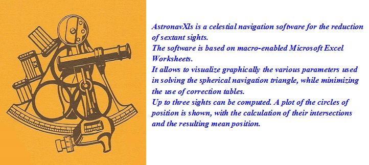
AstronavXls, version 13.0

In this new version, all three Sight data worksheets have been provided with a check box for meridian passage (midday) sights. Checking the midday sight checkbox on the Sight sheet transfers the corrected GHA value of the celestial body as the Assumed Position (DR) Longitude entry, after conversion to equivalent East or West longitude. The effect is to align the azimuth line of the celestial body to the observer’s meridian at the time of transit. The latitude is found at the intersection of the circle of position with the azimuth line. The observer’s coordinates at transit time are displayed in the Meridian Passage section on the LOP plot worksheet.

Prior to the advent of the GPS, surveyors determined benchmarks coordinates with great accuracy by averaging the meridian transit of several stars, using a theodolite. The new version of AstronavXls allows to test that technique with up to three meridian passage sights, by averaging the obtained coordinates, upon the click of a check box. The technique is not very useful on a moving boat, when one is limited by the time constraint of twilight and a real horizon. However it can very well be applied with an artificial horizon, at a fixed position, where time and available stars are no limits, for the sake of comparison with the more standard method of obtaining a fix. Personally, I made my own artificial horizon with an old 6-inches bathroom mirror, properly leveled using a precision surveyor level, accurate to 2 seconds of arc.